| Username |
Post |
| villain |
Posted
on 16-Apr-03 12:19 PM
This is a real picture..... it has nothing to do with Photoshop or any of those fancy tools.
|
| isolated freak |
Posted
on 16-Apr-03 12:24 PM
interesting..
|
| villain |
Posted
on 16-Apr-03 12:25 PM
Nice, no?
you like?
|
| isolated freak |
Posted
on 16-Apr-03 12:26 PM
how do i look at this pic or what am i to see in this pic?
|
| isolated freak |
Posted
on 16-Apr-03 12:27 PM
i liked it.. but i am yet to figure out what i am looking at
an abstract picture?
|
| isolated freak |
Posted
on 16-Apr-03 12:28 PM
am i looking at the map of UK or the UK from satellite pic?
|
| czar |
Posted
on 16-Apr-03 12:51 PM
IF, you correctly deduced that it is the UK you are looking at the top centre of the satellite picture.To the left of the UK is Ireland.
It clearly shows the progression of day and night. As you notice, daylight is on the left hand side of the picture, which is West. Whereas it is night time on the right hand side of the picture, which is East.
In the center right of the picture, you see the lights of the Benelux countries, Netherlands and further right, Germany. All ablaze with lights. OECD countries, with money to burn on electric lights.
Dead center is the large white patch of sand..the Sahara dessert, stretching through in wide swath from left to right. Just below are the fairly densely populated areas of Cote D'Ivoire (Ivory Coast), Senegal and other West African countries.
Jutting out into the Atlantic, just above North Africa is the country of Spain. The greenest part of that land mass is Portugal, west of Spain.
Hope that helps. My 2 cents. :)
|
| Logical Sense |
Posted
on 16-Apr-03 01:53 PM
Amazing Description czarji. Are you working for GPS or map digitize projects?
Friends, here is the political map to compare against czarji's description
My 2 cents
- iti
|
| czar |
Posted
on 16-Apr-03 02:56 PM
Now that you ask, zamana ma archinfo alikati chalaako thiyen, arey. Birsisakyo aba ta.
But what I wrote above was through actual observations made over a period of time. I was fortunate in that I mostly flew in the cockpit, so that gave me given me a fairly clear picture of the European, Middle Eastern and quite a bit of the Asian land mass. Its quite another view one gets from 45,000 feet at 3 am and one can see the curvature of the earth
Baanki zindagi ma Africa and South America bhyauney ho ki haina kunni.
Oh, on the top left edge of the picture, the white land mass is the edge of Greenland. Its a darn sight larger than its representation on the map.
|
| vivid |
Posted
on 16-Apr-03 02:56 PM
Villain ji, Nice picture.
Czar ji, perfect description to go with the picture.
Actaully the most densely lighted Benelux country is Belgium, the only nation to light every highway on the expanse of nuclear power, which they think nowadays is a great blunder they made in the past.
Added 2 cents from my side, :)
|
| Logical Sense |
Posted
on 16-Apr-03 03:31 PM
Don't want to by nosy, but, I can't connect the dots for czarji.
You are a pilot now who worked for DSI in the past? Hmm, what a change of career!!! Or, you are a S/W engineer who flew/flying as a hobby!!!
Logic is not working..... Help help!!!
|
| czar |
Posted
on 16-Apr-03 06:57 PM
Gol maal bho antarey, gol maal. :)
Logical sense, let's just say I've been priveleged to have had some marvellous opportunities in my life so far. Even if I don't have a thesaurus ..yet. :)
Cheers !
|
| czar |
Posted
on 16-Apr-03 06:57 PM
Gol maal bho antarey, gol maal. :)
Logical sense, let's just say I've been priveleged to have had some marvellous opportunities in my life so far. Even if I don't have a thesaurus ..yet. :)
Cheers !
|
| SITARA |
Posted
on 17-Apr-03 05:39 AM
CZAR ji:
Hehehe! Ma Maw usta say..."Be a movin target!" ;)
About the Thesaurus; ask Bhedo ji...I think he has tons to spare!
Logical Sense ji:
CZAR is a man of many faces... and each mask is unrelated! Don't let him golmaal your logic. :)
|
| isolated freak |
Posted
on 17-Apr-03 05:47 AM
so far:
CZAR has sghown his acquanitance with :
1. Computers
2. History
3. International Affairs
4. Radio-Coimmunication (not your song broadcasting radio)
5. GPS/GIS
hmm.. all unrelated but some similartities between 1 and 5.
He also wrote an interesting piece on early computer programmers of Nepal.
He admits in this thread that he used some computer programs.
so, he "might" be into computers.
my 40 rs yaar.. internet is mahangoi.. phone bill mahango..
heheh :-)
|
| isolated freak |
Posted
on 17-Apr-03 05:49 AM
heheh czar,
you don't have a thesarus.. dude, i am yet to buy a dictionary... satte, I don't own a damn dictionary, forget thesarus.
|
| isolated freak |
Posted
on 17-Apr-03 05:54 AM
hbmm a pilot! ok got itl...
|
| SITARA |
Posted
on 17-Apr-03 05:54 AM
IF Ji...
Me too! Suffering from NDS=No Dictionary Syndrome!
That is why my eespelling is as creative as yours! :P
I wish I could hire Bhedo ji's First World "NBAE"=Nepali Born American English Services and his brilliant-esque IQ services! :)
|
| isolated freak |
Posted
on 17-Apr-03 05:55 AM
kasto bich ko posting napadhera sabai kiss (oooops miss) khayo!!!!!@
|
| isolated freak |
Posted
on 17-Apr-03 05:57 AM
webster dictionary good or k bhancha oxfoird dictionary good? i'll have to get one ASAP.
heheh sitara, dictionary herna pani aaundaina malai ta...
|
| Rusty |
Posted
on 17-Apr-03 06:03 AM
Wow, Villian ko a nice pic, ani
Czar ko very nice description. Very interesting and informative.
|
| DHUMBASSE (DUMBASS) |
Posted
on 17-Apr-03 06:22 AM
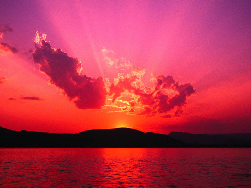
Sunset ko kura garda please allow me to post this picture I took while i was in jamaica...I hope you guys like it.
maile ya ko kura bangyauna khojeko hoina tara could not resist, no matter how hard i tried..

|
| DHUMBASSE (DUMBASS) |
Posted
on 17-Apr-03 06:32 AM
One more and I take a leave....

|
| Aliciaa |
Posted
on 17-Apr-03 06:35 AM
where is the other picture( one more) bhaneko.Jamaica and Bahamas are the coolest place.
|
| DHUMBASSE (DUMBASS) |
Posted
on 17-Apr-03 06:36 AM
Last try ....

|
| sbj |
Posted
on 17-Apr-03 07:32 AM
Hello,
Czar is giving BS big time. He FORGOT to mention that when that picture was circulated (I had seen it before) it came with a description. So, Mr. Czar did simple cut and paste and did not mention. Shame on you Czarji. You have to give credit where and when needed, you know. I just could not sit and do nothing. Sorry to burst your bubble Czarji.
Cheers!!!
sbj
|
| czar |
Posted
on 17-Apr-03 08:09 AM
Coming back to the satellite picture:
On the top right edge, you notice the Norwegian land mass pointing like a finger straight at Britain. With favourable tides and wind, it was a warmer and lush country to invade, which the Norsemen did.
Also note, the extensive ice cover in Norway, but just a few hundred miles to the south, UK shows no ice cover. Tis those, for those latitudes, warm currents circulating around those islands that keeps ole England n Ireland nice and lush.
As for sbj, your comments are predicated on the assumption that
A. a Gorkhey could not know much of geography or of satellite imagery.
B. the same bloke might even have travelled some.
C. worst of all, teh same fellow might be capable of writing, on occasion, some fairly clear writing
Please don't make the mistake of thinking that every one here is a stray mongrel yapping at the heels of every passerby. Or out here to impress with, lo n behold, cut n paste skills. Lawd almighty.
Further, don't count me as one, but there are loads of articulate, intelligent, well read and well travelled people here. Well heeled too. People of wit, humour and ability. This lot here are leaders of organizations, or will be in future. So look forward to presentation of amazing thoughts and high calibre writing.
No, don't go on a wild Google search to figure out if anyone has actually plagiarzed any work and claimed it as their own. Nope, these folks here are all genuine. All original works.
I am no tinhorn out for my fix of cheap thrills. Most places I speak of, I have travelled to and/or studied closely. Every river I speak of, I have swum in or drunk the waters of. No, I don't bs, and no, I don't need this or any other platform to bolster a fragile self-esteem.
And yes, my thir worl Englees is also genu-wine. So put that in your pipe and smoke it, it will add iron to your blood.
|
| SITARA |
Posted
on 17-Apr-03 08:41 AM
Dhumbasse ji:
Breathtakingly beautiful! I envy you. So, did you take an early morning *Sunrise Walk* like someone prescribed? :)
|
| SITARA |
Posted
on 17-Apr-03 08:47 AM
sbj:
Leetal No-ledge ees daanger-us!
Watch where you apply it! Sajhaites are not only well-heeled, well stocked and/or well equipped... you might find yourself hung, drawn and quartered by your unmentionables!
|
| Aliciaa |
Posted
on 17-Apr-03 08:56 AM
what a incredible picture
|
| DHUMBASSE (DUMBASS) |
Posted
on 17-Apr-03 09:00 AM
hajur !!
Bihani pakhako kura nai beglai ...la yeuta jawash bihana hidda hidaia ko..hai ta..

|
| czar |
Posted
on 17-Apr-03 09:04 AM
Villain, Dhumbass..lovely pictures. My appreciations !
Also, my apologies for my long winded harrumphing. No more from me. Not here anyways.
|
| SITARA |
Posted
on 17-Apr-03 09:11 AM
Wow!
The streak of smoky orange, flaring into a soft orange yellow....slowly melting into a deep bluish sky! What a contrast with the shadows of the jutting land and the ebony sillouettes of the sleeping boats!
Dhanyabad Hajur!
|
| MunnaMobile |
Posted
on 17-Apr-03 09:14 AM
The Sun never sets here.
|
| dhumbasse (dumbass) |
Posted
on 17-Apr-03 09:21 AM
La ma pani aba yeta bata taaaaaaaaaaaaaaap...Ye czar!!ye Czar!! pakhnush na bhnya..bistarai hide hundaina..daudinai parcha ..ma pani ta aai ra chu ni..kyaa..:P
|
| MunnaMobile |
Posted
on 17-Apr-03 09:21 AM

|
| rajunpl |
Posted
on 17-Apr-03 09:39 AM
ramro cha afno ta galti bhai halyo
|
| Poonte |
Posted
on 17-Apr-03 10:21 AM
Hamro Czar jyu...desh khayera sesh bhayeka? ;) dherai nakhau...uta Boston ka harulai jastai hola feri...chherauti le...baru Jivan Jal ko business garna jane haina Boston tira? :P
La, aaja mero ruta thuloooooooooo ghaando sidheko...ali ali fursad chha...uta tira ni post garna janchhu...
a, sanchi! Dhumbaa dai...tyo bikini wala haruko ni photu marula? Ghaando sidheko din...jos chalyachha ke malai taruni haru check out garna...natra Dhumbaa dai le nai g-string laako photo bhayeni hunchha...chalega
|
| DHUMBASSE (DUMBASS) |
Posted
on 17-Apr-03 10:25 AM
Cha kina nahune...check this out..
tara sanle marcha bho nagarau..baru khususkka email pathaula hunna..baru ke ho email address Poonte..
|
| Poonte |
Posted
on 17-Apr-03 11:39 AM
naam ma kilik gare hunna?
|
| SITARA |
Posted
on 17-Apr-03 12:08 PM
Munna Mobile ji:
Very Munna, Immobile Fingers there! :P
Is it Thailand or Burma? A form of greeting?
Like the Thumbs Up Finger in the Middle East means the same as the "Munna Immobile Fingers" like the one you posted!
|
| isolated freak |
Posted
on 17-Apr-03 12:13 PM
it looks likjes its from burma
|
| Arnico |
Posted
on 18-Apr-03 04:51 AM
Dumbass, nice photos!
I was going to comment on the original space-view image from Villain, but was traveling and could not post.
Here is what I had written... hope it has not lost its relevance... it was written when there were about 7-8 postings on this thread...
__________________________
What is a REAL picture?
If any image composed of colored pixels qualifies as a picture, then fine.
I got the impression though, that the image here is being presented as one satellite image taken in the visible range of the EM spectrum& that we are pretending that this is how the view would look to the human eye if we looked from where the satellite is located. That cannot be the case for at least the following reasons:
1) The ocean bottom topography is NOT visible from space. At least the ocean part is computer-generated imagery (3-D graphing of altitude data).
2) There are no clouds in the image. It is NEVER possible to get a view of an area of earth that big without a considerable part of it being obscured by clouds. The land portion may have the real visible colors based on real images& but it must be a composite of hundreds if not thousands of images taken on various days of small areas that were cloudfree at the time.
3) The �map projection� is not how one would see it in real life. Notice how the further north you go, the more distorted the image gets, for example the shape of Iceland. This imagine has longitude lines running parallel, as well as latitude lines equally spaced. (I forgot what that projection is called, it is not mercator, which conserves shape at the expense of distorting relative areas). We are looking at a projected image&a map&
To me this looks like a clever combination of three separate publicly available images:
(1) a sea surface map.
(2) a map/poster from about a decade ago (from NASA?) that was composed of thousands of cloud-free images of the earths� land surface.
(3) another cloud-free map/poster of �the earth at night� where the satellite detection of city lights at night was strongly amplified.
To me this looks like a some very clever manipulation with photoshop or with the raw image data from the 3 sources. Well, actually, downgrade that to �quite clever� from �very clever�. There is a flaw:
Sunlight is much stronger than city lights. During the day time whether streetlights are on or not has almost no impact on the perception of road color from the air. Yet in the Paris area as well as in parts of Belgium and around Barcelona, the city lights from the night view dominate over the landscape color that should be seen in sunlight&
Also, I am just wondering why the edge of the night shadow crosses the sahara in a straight line rather than a continuation of the curve it shows over Europe&
Anyway interesting picture to think about&
|
| Rusty |
Posted
on 18-Apr-03 06:17 AM
Villian,
The "Sunset" satellite pic was one of the best pictures I had ever seen. I showed it to my colleagues at work; everybody liked it so much that it's on their desktop background now. It really looks cool...Again, thanks for sharing that pic.
|
| Rusty |
Posted
on 18-Apr-03 06:49 AM
Arnico Ji,
Very nice analysis to prove the pic is nothing but a cleaver manipulation.
Last night, I was also wondering why there are no clouds in the image, and the ocean bottom is so visible. However, due to lack of enough knowledge about satellite pictures, I believed that it was real. I also surfed through the Internet, searching for other satellite pictures of other parts of the planet. But, I didn't find any picture that was close to this one... All I could find was blurry and overcastted pictures, much similar to what we see in weather channel.
Now, I am also giving the second thought that this must be the maneuvered picture; nonetheless I give credit to the manipulator, for crafting such a captivating image. Let's see if I can put real satellite image here....
|
| MunnaMobile |
Posted
on 18-Apr-03 09:03 AM
Sitaraji...The fingers in the pics are pretty immobile..But Munna is Mobile though..heheheh.
The pics are taken up north in Thailand..somewhere between the border of Thailand n Burma.
Next time I shall try to be more flexible even while posting:P
Munna Still Mobile
|
| DHUMBASSE (DUMBASS) |
Posted
on 18-Apr-03 09:24 AM
Halo Munna !! thank you for sharing your experience..hehe.
.thailand ra burmako border re.. very scary man!! is that how they greet outsiders ?
|
| suna |
Posted
on 18-Apr-03 11:39 AM
MunnaJI
:)
Did you show them how to pose for you pic? I have never seen you give your very mobile finger to anyone - I guess this is the closest I'll get to seeing that.
;)
|
| DHUMBASSE (DUMBASS) |
Posted
on 18-Apr-03 11:53 AM
oho suna katti din pachi...kata bepatta..welcome back..momo pakyera phursat nabha jasto cha..hehe
|
| MunnaMobile |
Posted
on 19-Apr-03 03:38 AM
Sunaaaaaaaaaaaaaaaa!!!...Glad to hear from you. Well! things hv changed since those goot ole dayz..now I hv become cordless n mobile..hehehehe
Khoi tyo chatroom ma entry nai hundai na. San lie katti help mange but to no avail. Seemz like I will hv to stay content by posting. Anyway missed you guyz...keep on posting.
|
| MunnaMobile |
Posted
on 19-Apr-03 03:53 AM
Sitaraji I hope this one is more mobile than you ever imagined.
Suna..I told you things changed..its just not my fingers only.
 http://www.sajha.com/uploads/imnotamerican111.jpg"> http://www.sajha.com/uploads/imnotamerican111.jpg">
|
| MunnaMobile |
Posted
on 19-Apr-03 04:00 AM

|
| vivid |
Posted
on 20-Apr-03 09:01 AM
Villain ji,
Finally I got it, anyway it really made me curious after all these transactions of accusations to and fro, so dicided to find it myself, :).
http://earthobservatory.nasa.gov/Study/LivingEarth/
Anybody interested can read it.
Curiosity kills the cat!
|